
01
Dholera Smart City
A planned greenfield city in Gujarat, designed with modern infrastructure standards and developed in phases within the Dholera SIR.
Why Dholera
Explore the development, infrastructure and connectivity shaping the wider Dholera region — and why location matters for land buyers.
The Basics
Dholera is a planned smart city taking shape in Gujarat, positioned as one of the anchor developments of the Delhi–Mumbai Industrial Corridor (DMIC) — one of the region's most significant infrastructure initiatives.
The project area is formally designated as the Dholera Special Investment Region (SIR), established under Gujarat's Special Investment Region legislation to plan and develop a large, purpose-built urban and industrial region.
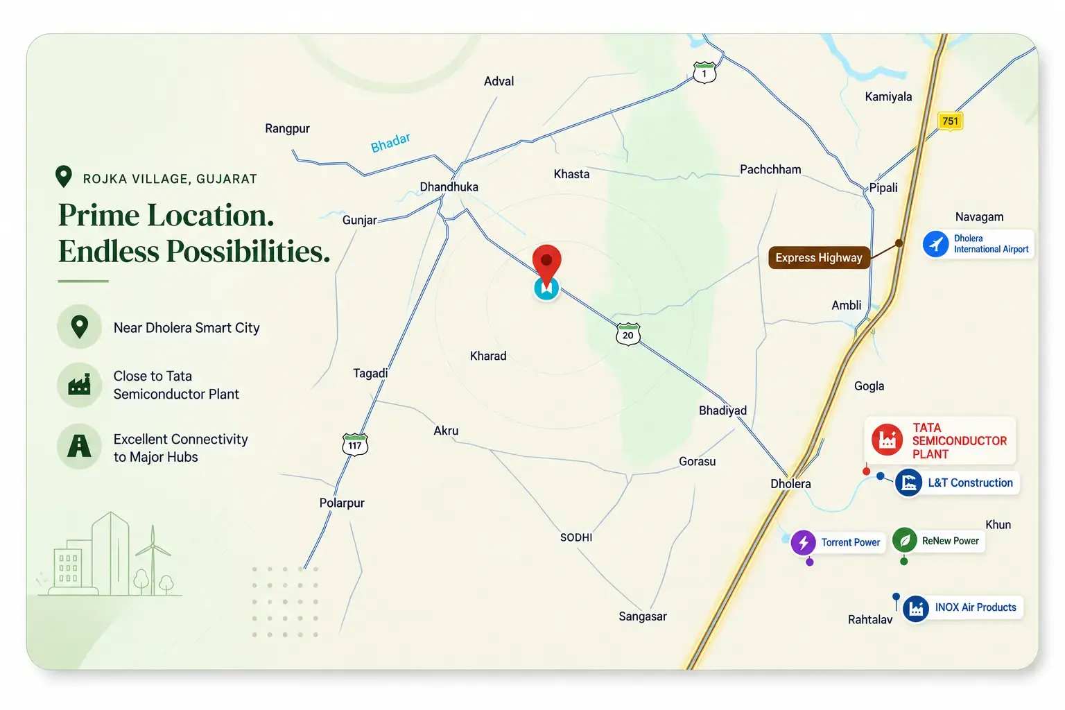
Development is being taken up in phases, beginning with an activation area that includes core infrastructure such as roads, drainage and utilities. Surrounding towns and villages — including Rojka — form the wider context in which this development is unfolding.
It is worth stating plainly: large planned developments take time. What follows is factual context about what is planned and under way, not a prediction of outcomes.
The Development Story
A factual, phase-by-phase view of the developments that define the Dholera region — without invented dates or exaggerated claims.
01 · The Framework
The Dholera Special Investment Region was established through dedicated state legislation, giving the region a formal planning and development framework rather than an ad-hoc expansion path.
Infrastructure
A planned greenfield city in Gujarat, designed with modern infrastructure standards and developed in phases within the Dholera SIR.
The formal planning designation covering the Dholera project area, established under Gujarat's SIR legislation to coordinate development across a large territory.
A greenfield airport nearing completion in the Dholera region — roughly 80% built as of mid-2026, with a 3,200-metre runway complete and passenger operations targeted for late 2026.
A ~109 km controlled-access expressway operational since March 2026, connecting Ahmedabad to the Dholera region in about 45 minutes. A new interchange to the Sardar Patel Ring Road is under construction.
A flagship industrial corridor project between Delhi and Mumbai, within which Dholera is positioned as one of the principal investment regions.
Dholera has been selected for India's first civilian 'Make in India' aircraft final assembly line, a partnership between Embraer and Adani Aviation Systems, with MRO hangars also planned in the region.
Dholera is attracting data centre investment, including a $10 billion Tillman Global project and an approximately Rs 25,000 crore L&T Vyoma AI data centre, with proposals for 17 GW of data centre capacity received by Gujarat under its new data centre policy.
These well-documented projects provide regional context. Exact distances and project details are verified before being shared with genuinely interested buyers.
For Land Buyers
Planned cities change the conversation around the land near them. When major infrastructure — airports, expressways, industrial zones — is developed in a region, it can influence long-term interest in the surrounding areas.
That does not mean outcomes are guaranteed. Development timelines move, and land value depends on many factors. But for buyers thinking long term, the trajectory of the wider region is one of the most important inputs into any location decision.
This is why we emphasise transparency about what is verified and what is still developing — so your evaluation of land near Dholera rests on facts rather than promises.
Location Relationship
From Gujarat's largest city to the planned development region, to the village where the property actually sits.
Distances are shared only once measured and verified during direct enquiry.
Ahmedabad
Gujarat's largest city
Dholera
The wider region
Dholera Smart City
Planned development area
Rojka Village
Property village
The Property
Available for site visit
Land Near Dholera
See the actual property in Rojka Village and evaluate the region from the ground.