
Location Clarity
Land Outside The Dholera SIR
The Dholera Special Investment Region has a defined legal boundary covering 22 villages. Land beside that boundary is not the same thing as land inside it — here is the difference, stated plainly.
Straight Answer
The property on this site is outside the boundary
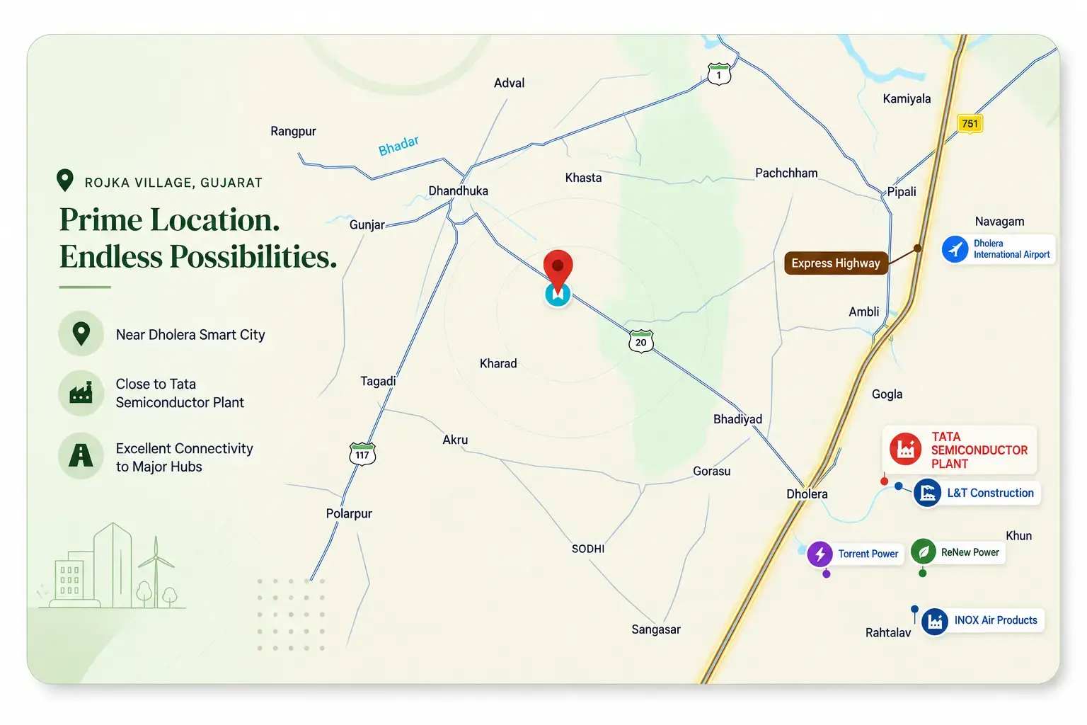
The featured property is in Rojka Village, Dhandhuka taluka, Ahmedabad district. Rojka is not one of the villages inside the Dholera Special Investment Region. It sits beside the SIR rather than within it.
This is stated here rather than left for a buyer to discover later, because the distinction is the single most important fact about this property's location — and because land outside the boundary is sometimes marketed using the Dholera name without that qualification.
The Legal Position
What the SIR boundary legally is
The Dholera Special Investment Region is a formally notified planning region, not a general marketing label. Gujarat's Special Investment Region Act, 2009 — in force from 6 January 2009 — gives the State Government the power to declare Special Investment Regions, and the Dholera SIR was created under that framework.
Development and administration sit with the Dholera Special Investment Region Development Authority (DSIRDA), which executes town planning schemes, frames development controls and approves development plans inside the region. A separate Special Purpose Vehicle, Dholera Industrial City Development Limited (DICDL), handles infrastructure implementation and land allotment.
By the authority's own published figures, the SIR spans approximately 920 sq km and encompasses 22 villages — all of them in Dholera taluka. Under Town Planning Schemes 1 to 6 it covers roughly 422 sq km, with Phase I covering about 153 sq km across TP1 and TP2. The first built-out phase, the Activation Area, is about 22.54 sq km.
- Legal basis
- Gujarat Special Investment Region Act, 2009
- Planning authority
- DSIRDA
- Infrastructure body
- DICDL
- Total planned area
- Approximately 920 sq km
- Area under TP schemes 1–6
- Approximately 422 sq km
- Phase I (TP1 and TP2)
- Approximately 153 sq km
- Activation Area built so far
- Approximately 22.54 sq km
- Villages inside the SIR
- 22, all in Dholera taluka
Do This Yourself
How to verify the boundary yourself
The boundary is a matter of public record, and checking it takes minutes rather than relying on a seller's description. The Dholera SIR portal publishes development planning information, town planning schemes, development permissions and notifications, maintained by DICDL.
- 01
Open the official Dholera SIR portal at dholera.gujarat.gov.in and use the planning section for town planning schemes, the villages map and development permissions
- 02
Look for the village concerned in the authority's published material — the region is described as 22 villages of Dholera taluka, so a village in a different taluka is a useful early signal
- 03
Ask the seller directly which taluka and village the parcel sits in, and ask for the 7/12 land record extract and the survey numbers
- 04
Confirm the land's classification and any conversion status through Gujarat's official revenue records rather than a brochure
- 05
Where a parcel's future zoning matters to your decision, request the relevant development permission in writing from the authority rather than relying on a verbal assurance
Why This Page Exists
Why this page exists
Land outside the SIR boundary is sometimes listed using the Dholera name, with 'near Dholera' doing work that 'inside Dholera SIR' would have to do. That is not fraud, and most sellers are not hiding anything — 'Dholera' is a widely used regional label, and the Dholera region genuinely extends well beyond the notified boundary.
It is still a material omission, because the boundary is what determines which regulatory protections apply to a parcel. A buyer who believes a plot is inside the SIR when it is not has evaluated the land against the wrong set of assumptions.
Publishing this distinction openly is a low-cost standard, and it is the standard this site holds itself to. If you are comparing parcels, the useful question is not how close a listing says it is to Dholera — it is whether the parcel is inside the notified boundary, and how you verified that.
Consider This
What a buyer gives up outside the boundary
Being outside the SIR is not a defect. Land outside the boundary can be entirely suitable for agriculture, residential, commercial or industrial use, subject to its own classification and approvals. What changes is which statutory protections and infrastructure commitments attach to the land.
A buyer outside the boundary should understand the following before proceeding.
No town planning scheme protection
The town planning schemes, development controls and urban design regulations framed by DSIRDA apply inside the region. Outside it, your land is governed by the classification and zoning that applies to its own village and taluka, which may change.
No DSIRDA no-objection or allotment route
Land allotment inside the SIR runs through DSIRDA and DICDL under defined policies. Outside the boundary there is no equivalent statutory route, and no allotment from the authority.
No committed SIR infrastructure
The trunk infrastructure being built inside the Activation Area — roads, water, power, data networks — is planned and delivered for the region inside the boundary. Being adjacent to it is not the same as being connected to it, and it should not be presented as though it were.
NA conversion and future zoning risk sits with you
Agricultural land outside the boundary is generally non-agricultural (NA) land, and any conversion to a developed or non-agricultural use is a separate process with its own conditions, timeline and cost. Future zoning decisions affecting the village are also outside a buyer's control.
Classification risk stays open for longer
Land use permissions and road access improvements depend on the village's own classification and on decisions taken at taluka and state level, rather than on a regional development authority with a published plan.
Buyer Checklist
What to verify before you buy
If you are evaluating land in the wider Dholera region, this is the sequence we would follow. None of it requires trusting a seller's description.
- 01
Establish the exact village and taluka from the 7/12 extract and the physical record, not from a listing headline
- 02
Check whether that village appears in the authority's published list of SIR villages
- 03
Confirm the current land classification and whether any conversion has been applied for or granted
- 04
Verify ownership and encumbrance through official revenue records and your own legal advisor
- 05
Walk the access route and note the road width, surface and whether access is settled or contested
- 06
Establish what the intended use requires, and whether that permission exists for this classification today
- 07
Treat connectivity and infrastructure claims as regional until you have confirmed them for the specific parcel
Rojka Specifically
How Rojka compares to villages inside the boundary
Rojka's position is a matter of geography and administration, not of quality. It is worth being precise about what is different and what is not, because the honest version is more useful to a buyer than either reassurance or alarm.
Same region, different administrative status
Rojka sits in the same wider Dholera region and benefits from the same regional connectivity projects. What differs is that it is not administered as part of the SIR, so SIR schemes and protections do not apply to it.
Proximity without inclusion
Rojka is among the closer villages to the SIR boundary without being inside it. That proximity is real and it is the reason the area is of interest — but proximity is a distance, and boundary membership is a legal status. Only one of the two is yours to rely on.
Independent land decisions
For a parcel in Rojka, the decisions that matter most to its use are made through the village's own classification, taluka and state processes — not through DSIRDA. Buyers who are comfortable with that trade are the buyers this land suits.
In Short
Where honesty stops being optional
A region's growth is a reasonable thing to weigh when evaluating land. What is not reasonable is pricing a parcel against benefits that attach to a different piece of land. The boundary is checkable, and it is the first thing worth checking.
Our position is that stating this plainly costs us nothing we were entitled to claim, and it means a serious buyer starts from accurate assumptions. Verified distances, boundary details and parcel specifics for this property are shared directly with interested buyers during enquiry or a site visit.
Looking for a specific parcel? View the property or arrange a site visit.
Boundary Questions
Ask About This Specific Parcel
Speak directly with the owner about village, taluka, classification, access and verified distances — details shared during genuine enquiry.
- +91 98797 40653
- primedholera@gmail.com
- Rojka Village, Gujarat